Finding Coordinates
How do I get coordinates to enter into interactive maps?
If you are placing a cache you must use your GPS to get the correct coordinates. The geocaching website uses coordinates in decimal degrees - HDDD° MM.MMM - which look like this N56°10.240 W003°22.260. Some of the interactive maps available to check locations to see if they are in nature reserves or other environmentally sensitive locations need coordinates in the Ordnance Survey British Grid Reference. Some landowners may also request coordinates in this format. This divides the UK into 100Km grid squares each with a two letter identification and then within each square a 6 or 10 digit number giving the eastings and northings. A grid reference looks like this NT1479398699 (or NT147986 if it's only 6 digits). The 10 digit number gives an accuracy on the map to 1 meter, the 6 digit reference gives an accuracy on the map to 100 meters. For more information about the OS GB grid click here (PDF document download).
The pages in this Wiki that describe the interactive maps show you what format you need to use. If your cache has been disabled because it is in such a location the reviewer will have given you the correct coordinates to check in the reviewer note).
Getting Coordinates from Streetmap
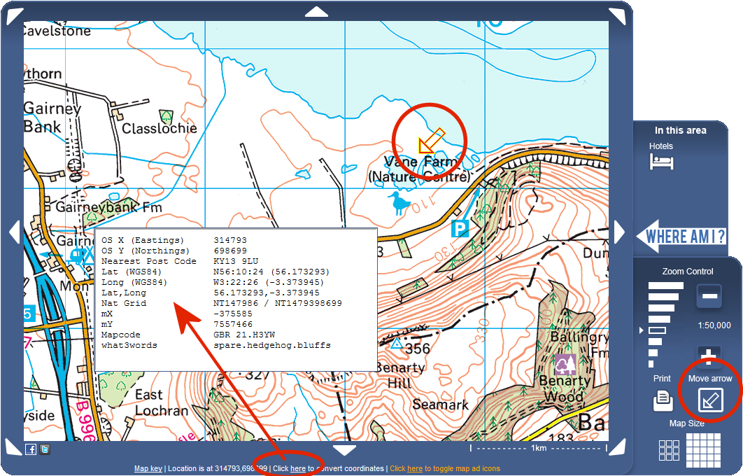
Click here to open Streetmap.
Streetmap uses the Ordnance Survey 1:50000 or 1:25000 scale maps and are the most detailed to use for the UK.
Open Streetmap and enter either a placename or postcode. When the map opens you can use the + and - zoom control (lower right) to zoom from the default 1:50000 OS map to the larger scale 1:25000 scale map. You can also move the arrow using the Move Arrow command and just click and drag to pan the map. Once the arrow is in the correct place click on the link below the map to convert coordinates. You can then copy the coordinates you need into the interactive map.
There is also a very useful link to open Streetmap directly using any coordinates (or postcode) and you can then use the Streetmap convert option to get the coordinates in any format. The link is called MapIt! Click here to open MapIt!
Getting Coordinates from Google Maps - Map or Satellite view
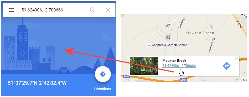
You can use either the map or satellite view with Google Maps. When you've got your location just click the mouse and grey teardorp marker appears with the coordinates below in decimal degrees. If you click these the location zooms in and in the pop up box the coords are shown in two formats, decimal degrees: 51.624906 -2.700666 and degrees, minutes and seconds 51°37'29.7"N 2°42'02.4"W.
Converting coordinates
There are many websites that let you convert coordinates from one format to another.
http://www.nearby.org.uk/coord.cgi - this site will recognise the OS GB grid references and also convert to them.
http://boulter.com/gps/ - recognises most coordinate formats.