Historical Sites

Table of Contents
Introduction
Guidelines
Geocaches are not placed in restricted, prohibited or otherwise inappropriate locations - The cache placement is in an area that is highly sensitive to additional foot and/or vehicular traffic including, but not limited to, archaeological sites, historical sites and cemeteries.
Caches in archaeological sites such as iron age hill forts, monasteries, abbeys, Roman sites, barrows, settlements or enclosures or other historically sensitive locations* are not allowed unless you can provide clear proof from the organisation that owns/manages the site that the cache location is approved.
Many sites are of such importance they are scheduled as ancient monuments (SAM) and they are protected by law.
You may however use such sites as 'virtual' clues and questions to answer for multi-caches/unknown caches, but the final location or any physical stages must not be within the boundaries of such sites without permission. Please note that the guideline above still applies to these 'virtual' stages in case the extra traffic of people searching may cause damage to the site.
*This is not an exhaustive list. Reviewers will use their discretion when reviewing caches believed to be in such locations and may request more information from the cache owner.
There are various interactive maps referred to in the following text that will help you identify sites around the UK.
Identifying Archaeological Sites and Interactive Maps
United Kingdom - generalThe Ordnance Survey 1:50000 scale (Landranger) maps do show historical sites for the whole of England, Wales and Scotland but the actual boundaries are not always clearly defined. EnglandThe government MAGIC map shows Scheduled Ancient Monuments and will also give you details about the site. WalesThe Lle Geo-Portal has a basic map showing the locations of all the CADW scheduled sites. Click here to open the portal page then click the Preview tab to view the map. Unfortunately the map doesn't give any details of the site. The map is also very slow to load the layers sometimes. For more detailed information about the site you can use the The Royal Commission on the Ancient and Historical Monuments of Wales (RCAHMW) map. You can also download a KML file of all SAM sites from the Lle Geo-Portal site that will open in Google Earth. You can download Google Earth free for the PC or as an app for Android or Apple. ScotlandThe PastMap provided by RCHAMS and Historic Scotland shows the extent of the historical site and gives details about it including information that may help you get permission. |
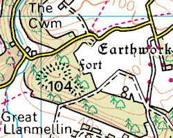
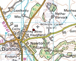
Iron age hill fort on the OS 1:50 scale map
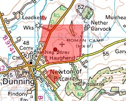
Scheduled Ancient Monument (SAM) on the MAGIC map (England only) |
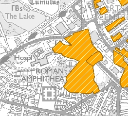
Archaeological site on the OS 1:50 scale map
|
How to get permission
England
Scheduled Ancient Monuments (SAM) are scheduled by English Heritage who may be able to give permission. Some sites are owned or managed privately or may be on land owned or managed by other organisations like the National Trust or Forestry Commission. You should also approach these for help getting permission.
Wales
Historical and archaeological sites are scheduled by CADW who may be able to give permission. Some sites are owned or managed privately or may be on land owned or managed by other organisations like the National Trust for Wales or Forestry Commission Wales. You should also approach these for help getting permission.
Scotland
Historical and archaeological sites are scheduled by the Royal Commission on the Ancient and Historical Monuments of Scotland (RCAHMS) who may be able to give permission. Some sites are owned or managed privately or may be on land owned or managed by other organisations like the National Trust for Scotland or Forestry Commission Scotland. You should also approach these for help getting permission.