Nature Reserves and Sites of Special Scientific Interest
Introduction
In the UK there are nationally important reserves which are scheduled by various government departments as well as local ones owned and run by local Wildlife Trusts or local authorities. There are also reserves owned or managed by the Royal Society for the Protection of Birds (RSPB). These reserves may also be (or include) Sites of Special Scientific Interest (SSSI). Caches on such reserves or SSSI's will not be published unless proof of permission is provided. Some wildlife trusts do not allow geocaching at all.
Nature Reserves (National and local)
National Nature Reserves (NNR) are scheduled by Natural England (NE), Scottish Natural Heritage (SNH) and Natural Resources Wales (NRW). NNR's have strict legal protection. They are mostly managed by the scheduling authority but many are managed by local wildlife trusts or organisations like the National Trust and Forestry Commission for example. Local Nature reserves (LN) are usually managed by one of the many Wildlife Trusts around the UK or sometimes a local council.
Sites of Special Scientific Interest
These are scheduled by Natural England (NE), Scottish Natural Heritage (SNH) and Natural Resources Wales (NRW). SSSI's have strict legal protection and the landowner is responsible for their upkeep and management. You may find that NE, SNH or NRW may be able help with permission as the scheduling authorities but may not necessarily give that permission themselves. You may need to contact the landowner directly. Many SSSI's are owned/managed by organisations like the National Trust and Forestry Commission.
The websites shown below in the section How to get permission allow you to search for NNR's, LN's and SSSI's and may also provide information about who manages them to help with getting permission.
Details of those wildlife trusts and other organisations that have agreements may be found in the Landowner Agreements Database.
There are various interactive maps referred to in the following text. Links to them (and how to use the maps) are shown here.
How to identify reserves and SSSI's
United Kingdom - generalNational nature reserves are indicated on the 1:50,000 Ordnance Survey (OS) maps with a blue bird symbol. Local nature reserves (including RSPB) are not always shown on the OS maps and SSSI's are not shown either. This does mean the OS maps are not very useful to locate such areas. A much better map is the government sponsored Multi Agency Geographic Information for the Countryside map known as MAGIC. This shows a large amount of information however it varies in coverage around the UK. The paragraph sections below will show exactly what MAGIC covers. Click here to see how to use this map - there is a very easy link that lets you enter coordinates and it then shows you the location with the various land areas highlighted. EnglandThe MAGIC map shows national, local and RSPB reserves as well as SSSI's. Some smaller local run reserves may not be shown on the map. WalesThe Data Map Wales shows National and Local Nature Reserves and SSSI's. The map doesn't give you any detail about the location. If you want more detail it is suggested you Google the reserve name.
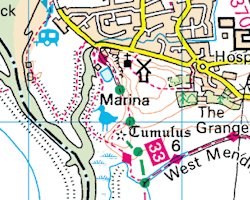
ScotlandThe MAGIC map shows national nature reserves and SSSI's. Scottish Natural Heritage (SNH) have an interactive map that shows SSSI's and nature reserves and which may include contact information. | Click on a map for a larger image. Nature Reserve on the OS 1:50 scale map
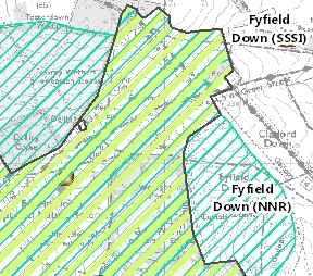
National Nature reserve and SSSI on the MAGIC map
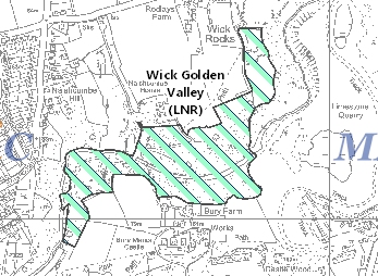
Local Nature reserve on the MAGIC map |
How to get permission
Local Nature reserves | |
National Nature Reserves (NNR) | |
Sites of Special Scientific Interest (SSSI) |